
Partner
Field-to-finish mapping workflows powered by Mach9 + Phoenix LiDAR
Learn how Mach9's AI-powered feature extraction software accelerates project delivery for Phoenix laser scanning customers.

Workflow
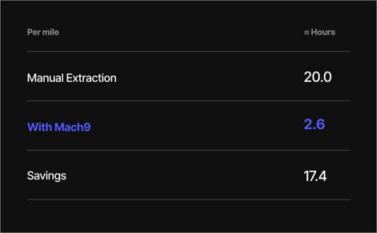
Create CAD and GIS models from laser scan data in hours, not weeks
Mach9 Digital Surveyor helps surveying, geospatial, and engineering organizations speed up survey, construction, and asset management projects with automated feature extraction. Together, Mach9 Digital Surveyor and Phoenix mobile mapping systems help customers deliver mapping projects faster from a single city block up to statewide and nationwide programs.
Compatible with Phoenix mobile mapping systems
Mach9 Digital Surveyor supports Phoenix Ranger, Scout, and Recon-XT mobile mapping systems. Digital Surveyor has no problem handling massive datasets spanning hundreds of miles so you don't have to break down a project into multiple chunks for delivery.


Seamlessly import data from Spatial Explorer to Mach9 Digital Surveyor
Mach9 provides clear and easy steps for you to bring your data from Spatial Explorer to Mach9 Digital Surveyor. Mach9 takes in non-proprietary, interoperable data formats, so you don’t have to handle complex data and file conversion.
Extract features faster with AI-assisted workflows
Mach9 Digital Surveyor boosts drafting efficiency with smart suggestions and automated feature extraction. Digital Surveyor provides powerful yet intuitive workflows so you are always in control. Digital Surveyor's cloud-based CAD experience allows you to deliver projects anywhere, and share work with the team or clients anytime.
Exports designed to integrate into your existing project workflows
Mach9 Digital Surveyor delivers extracted features in standard CAD and GIS formats that plug directly into downstream software such as Autodesk Civil 3D, Bentley Microstation, Esri ArcGIS, and Trimble Business Center. Define reusable templates with custom feature codes, CAD layers, and geodatabase schemas to deliver complete design, construction, and asset-management products.


